| |
|
|
DIGITAL GEORGIAN TOPOGRAPHIC MAPS
Year: 2009
Client: Ministry of Environmental Protection and Natrual Resource Management
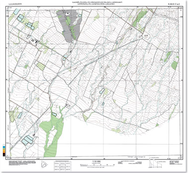
Field inspection of accuracy of relief illustrated on old topographic maps and update of state geodetic network points and leveling signs have been conducted at the initial stage of production of digital Georgian topographic maps at 1:10 000 scale for the territories adjacent to the villages of Samtatskaro and Machkhalroso at the Georgian-Azerbaijan state border (total area 780.7 sq. km.). Field works also included development of network to be surveyed and vertical-height binding of stereo satellite images. Orthophoto plan, Digital Elevation Model (DEM) and Digital Terrain Model (DTM) were developed in 1942 and UTM/WGS - 84 coordinate system.
GeoGraphic developed unified geodatabase structure and entire symbology for Georgian digital topographic maps that will facilitate to high quality Georgian topographic map production in the future.
The final product is Georgian digital topographic maps at 1:10 000 scale in 1942 coordinate system and relevant geodatabase.
|
 |
| |
Current version of 1:10 000 Georgian topographic map |
Cadastral and Topo-Geodetic Survey of Pipelines in Georgia
Year: 2009
Client: “SOCAR Georgia”
Cadastral survey was done based on the orthophotos at 1:2000 scale. Surveys included pipelines owned by SOCAR Georgia as well as pipelines owned by municipalities and other owners in Chokhatauri, Lanchkhuti, Ozurgeti, Tskaltubo, Akhmeta, Kvareli, Gardabani, Mtskheta, Abasha districts. The total length of surveyed pipelines made up 540 km.
Field survey results have been integrated into the entire geodatabase. Comprehensive information and key parameters of pipelines include geographical location, length, diameter, height/depth, pressure, location of fittings.
Cadastral maps have been produced with the aim of registration at the National Agency of Public Registry.
|
|